

Rarely does the typically dry Cooper Creek region in Australia transform into a flourishing oasis, yet following an intense rainfall event in 2025, this phenomenon unfolded vividly. Historic floodwaters swept across the landscape, turning the once parched and cracked earth into a lush green space. This extraordinary shift was documented by NASA satellites, revealing a breathtaking and fleeting revival in an area long known for its harsh aridity and barrenness. NASA’s Earth Observatory utilized satellite imaging to monitor these remarkable environmental changes.
Floodwaters Spark Unexpected Natural Bloom
A record-setting rainstorm dumped over a year's worth of precipitation within just seven days, converting parts of western Queensland into a temporary aquatic haven. While these floods caused disruption—submerging communities and prompting evacuations—they also ignited a resurgence of plant and animal life across the drought-stricken region.
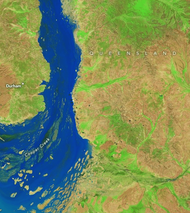
According to NASA’s Earth Observatory, floodwaters transformed Cooper Creek into a swiftly flowing river network, breaking flood records and inundating entire towns. After many dry years, the area began to display vibrant signs of renewal.

The exceptional rainfall triggered a rare ecological reboot. As the water levels fell, verdant vegetation emerged across the landscape, revitalizing habitats long dormant. This explosive greening was vital for boosting local biodiversity.
“The silver lining of this flooding is a massive boost to the longer-term biodiversity,” says Geoff Penton, an operations manager working in the region. Though the damage to farmland and infrastructure was severe, the longer-term effects could revitalize the area’s ecosystems in ways that are hard to predict.
Cooper Creek’s Crucial Role in Regional Ecology
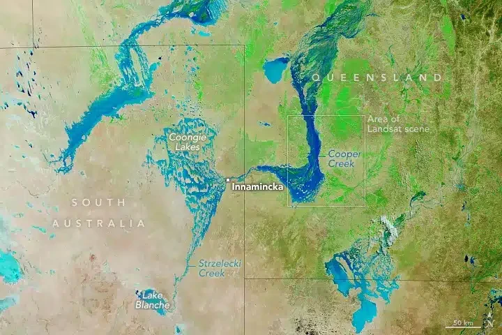
Cooper Creek holds a unique position within the expansive Lake Eyre Basin, an inland drainage system where water does not reach the ocean but evaporates or pools in salt flats. Flooding events like the one in 2025 are infrequent but essential, injecting new vitality into an otherwise arid environment. NASA reports that inland flooding initiates a sequence of ecological processes that support the region’s delicate habitats.
During such floods, thousands of dormant crustacean and invertebrate eggs are awakened from their resting state. These small organisms form the base of a complex food web that supports a variety of wildlife, including fish populations and migratory birds.
Advanced Satellite Tools Illuminate Desert Revival
The ability of NASA to observe such a dramatic ecological turnaround showcases the sophistication of contemporary satellite imaging. Instruments like Landsat and the Moderate Resolution Imaging Spectroradiometer (MODIS) recorded false-color imagery that effectively reveals the presence of water and vegetation changes.
“The images were acquired with the OLI-2 (Operational Land Imager-2) on Landsat 9. The band combination (6-5-4) helps distinguish where water and vegetation are present,” noted the statement from the American space agency.
This valuable information aids conservationists, hydrologists, and local guides by providing precise data needed to understand and respond to the environmental impacts of these floods.
- Categories:
- Nasa


0 comments
Sign in to Comment