
A set of long-lost aerial photographs captured by a U.S. Navy plane in 1966 has emerged as a vital resource for understanding the behavior of Antarctica’s ice shelves. Researchers at the University of Copenhagen have fused these historic images with current satellite observations to document the dramatic disintegration of the Wordie Ice Shelf.
Unearthing a Forgotten Record
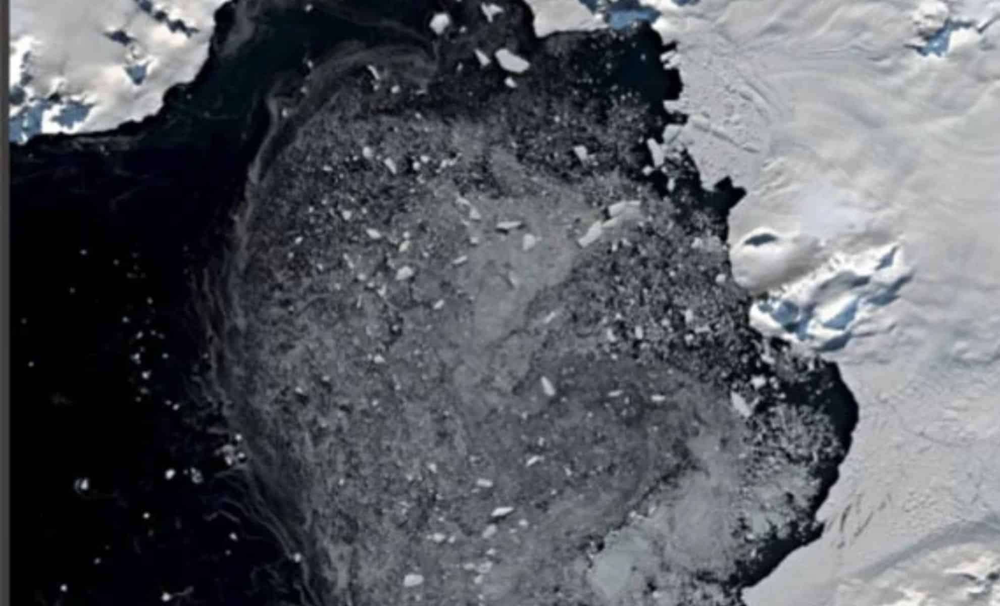
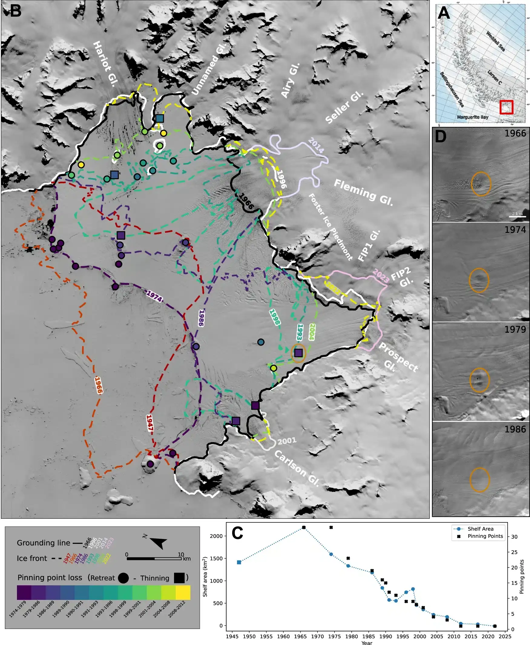
On November 28, 1966, a U.S. aircraft conducted a flight over the Antarctic Peninsula, located just off the southern tip of Chile. A Navy photographer aboard the mission took various snapshots of the icy terrain, including views of the Wordie Ice Shelf. Initially intended for mapping purposes, these images have now proven crucial in tracing events that led to the near-total collapse of the ice shelf within the following 30 years, triggering a sequence of impacts that continue to influence global sea levels.
The disintegration of the Wordie Ice Shelf released a large block of ice, enabling adjacent glaciers to accelerate their flow into the ocean. This process, which contributes to sea-level rise, may occur faster than previously estimated, notably when larger ice shelves such as Ronne and Ross are involved.

Subsurface Melting Drives Breakdown
The new research reshapes prior beliefs about what causes ice shelf collapse. While it was once thought that rising air temperatures and surface meltwater lakes were key culprits, the study reveals that warming ocean waters melting the ice from underneath is the dominant factor.
“Our study confirms that increasing sea temperatures have led to basal melting beneath the floating ice shelf, which primarily drove the Wordie collapse,” stated Mads Dømgaard, lead author from the Department of Geosciences and Natural Resource Management at the University of Copenhagen.
Tracking Ice Disintegration Over Time
By merging historical photos from flights conducted between 1966 and 1969 with recent satellite data, scientists created detailed time-lapse reconstructions of the Wordie Ice Shelf’s decline. Utilizing structure-from-motion photogrammetry, a technique that builds precise 3D models from overlapping images, the team measured the ice’s surface contours, thickness, and flow speed with remarkable precision.
These innovative datasets are expected to refine sea-level rise projections, allowing policymakers to better anticipate and prepare for the effects of climate change.
Implications for Global Sea Levels
Though smaller than some Antarctic ice shelves, the Wordie Ice Shelf’s demise serves as a significant indication of potential large-scale ice loss. Antarctica’s vast ice formations could collectively raise sea levels by up to five meters if they collapse. Because of Antarctica’s gravitational effect drawing ocean waters southward, losing ice mass there would elevate sea levels worldwide, especially threatening Northern Hemisphere coastlines.
“Our results suggest that ice shelf collapses may proceed more gradually than previously thought,” explained Anders Anker Bjørk, co-author and assistant professor at the University of Copenhagen. “This might reduce the likelihood of an immediate, rapid rise in sea levels from Antarctic melting, according to insights from this and related research.”
Nevertheless, Bjørk warns this slower pace poses its own challenges. “Ice shelf decline already resembled a massive slow-moving vessel needing significant effort to alter. Our findings indicate an even more prolonged collapse trajectory, making it more difficult to halt once it begins. This is a clear call for urgent action to reduce greenhouse gas emissions now rather than delay efforts for the future.”
- Categories:
- News


0 comments
Sign in to Comment