

In 2023, an unusual pattern of seismic activity puzzled scientists for over a week. Repeating every 90 seconds across nine days, these signals first emerged in September and resurfaced in October, sparking intense scientific scrutiny. Originally thought to be caused by a seiche—oscillating waves trapped in enclosed water bodies—the exact cause eluded researchers until NASA’s cutting-edge Surface Water Ocean Topography (SWOT) satellite supplied vital insights.
Tracing the Source of the Seismic Pulses
Researchers identified the source of the peculiar pulses in Greenland’s Dickson Fjord. The initial hypothesis linked the signals to a seiche, which results from water rocking back and forth within confined spaces. Early signs seemed to connect the phenomenon to a massive landslide-induced megatsunami in the area.
Yet verifying this theory proved challenging. Existing seismic sensors were unable to collect the fine detail necessary to confirm the origin. Data was scarce or lacked the accuracy needed, leaving the rhythmic signals mysterious despite numerous attempts to align them with environmental occurrences.

How NASA’s SWOT Satellite Solved the Puzzle
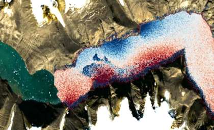
The breakthrough came when Dr. Thomas Monahan and his research group at Oxford University turned to NASA’s SWOT satellite for answers. Equipped with the revolutionary KaRIn (Ka-band Radar Interferometer) instrument, SWOT delivers unparalleled, high-resolution surface water measurements. Unlike previous satellites, it could accurately detect subtle changes in the fjord’s water levels, exposing waves generated by the seiche.
Monahan’s team analyzed every satellite overpass during the critical months, creating comprehensive models of how water moved inside the fjord after the tsunami impact. Their findings revealed wave height fluctuations reaching nearly 2 meters (approximately 6.5 feet), conclusively matching the seismic signatures of a fading seiche.
Insights into the Seiche Mechanism
Seiches are not limited to fjords; they also develop in other confined or semi-enclosed waters such as lakes. In Dickson Fjord’s case, strong winds, shifts in atmospheric pressure, and a colossal tsunami combined to generate perfect conditions for the seiche. The tsunami’s powerful surge displaced vast quantities of water, inducing oscillations that persisted for days. These water movements were responsible for the distinctive seismic pulses recorded.
Though tsunamis themselves produce seismic activity, the longer-period signals from the seiche induced by the landslide were unique and hard to detect with outdated satellite technology. SWOT’s capacity for persistent, fine-scale monitoring was pivotal in capturing and deciphering these subtle dynamics.
Advancing Earth Science with Cutting-Edge Satellites
This discovery underscores the transformative impact of innovative Earth observation tools. SWOT’s exceptional detail in monitoring aquatic environments enables scientists to explore natural processes in rugged, remote places like fjords with unprecedented clarity. This marks a significant step forward in understanding oceanic phenomena linked to seismic events.
As Dr. Monahan articulated, “our research demonstrates the potential of next-generation satellite Earth observation to illuminate complex processes. SWOT represents a breakthrough platform for exploring oceanic behavior in challenging regions previously unreachable by older satellites.”
The findings pave the way for better comprehension of ocean-seismic interactions, promising new insights into Earth's dynamic systems.
- Categories:
- News


0 comments
Sign in to Comment