
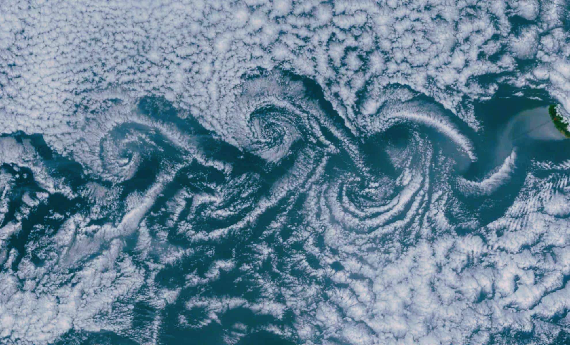
In a captivating 2015 satellite snapshot, NASA captured a rare atmospheric event identified as von Kármán vortices forming over multiple islands in the Atlantic Ocean. This image, taken by NASA’s Terra satellite on May 20, 2015, spans an area roughly 260,000 square miles. It reveals vortex patterns emerging from Madeira, the Canary Islands, and other surrounding locations. The scale of this display ranks among the largest von Kármán vortex occurrences documented over the ocean, enriching our scientific grasp of wind flows and atmospheric turbulence.
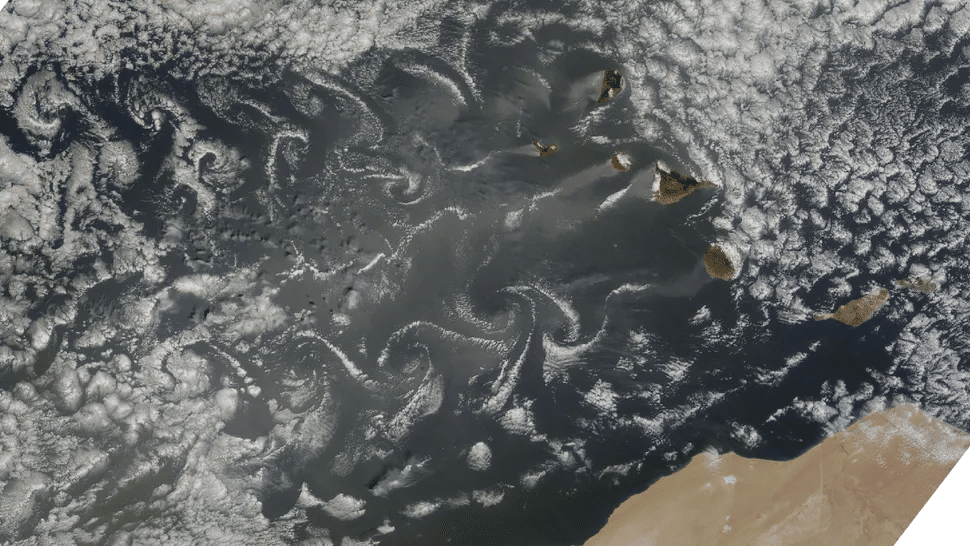
NASA’s Earth Observatory has also highlighted similar vortex activity, emphasizing the Canary Islands and their significant role in triggering these formations. The NASA Earth Observatory’s detailed exploration delves into how land features generate these swirling clouds, providing valuable insights into the atmospheric dynamics prevalent in various parts of the world. Von Kármán vortices, especially those more intense than usual near the Canary Islands, are pivotal to meteorologists and climatologists studying how airflow interacts with unique landforms such as islands and mountainous terrain.
Understanding Von Kármán Vortices
Von Kármán vortices represent a captivating weather phenomenon where wind passing over an obstruction disrupts airflow, creating spiral cloud formations. When air encounters a physical barrier, alternating vortices develop downstream, often made visible by clouds trapped in the circulating currents. These spirals, appearing in sequences with rotating pairs spinning in opposite directions, can vary widely in scale and intensity but are especially impressive over islands and mountainous regions.

The Terra satellite image shows several clusters of vortices forming around no fewer than six Atlantic islands, with the most striking swirls seen near Madeira. This event offers a unique view into atmospheric mechanics and how local wind patterns interact with terrain. The scientific study of these vortices enhances our capacity to forecast weather and refine climate models by clarifying air movement behaviors in the atmosphere.
Mechanics Behind Von Kármán Vortex Formation
The genesis of von Kármán vortices stems from wind encountering an obstacle such as a mountain or island. This interaction causes airflow to split and rotate into alternating vortex patterns along the lee side. These rotating air masses move downstream, with cloud formations often highlighting these phenomena. Such vortices are most noticeable where robust winds collide with prominent mountain ranges or island terrain.
The remarkable clarity and scale of vortices near Madeira and the Canary Islands in 2015 arise from their unique geography and climatic conditions. These island groups feature steep mountains and sit in zones influenced by steady trade winds, producing frequent and strong atmospheric disruptions that give rise to von Kármán vortices. The resulting cloud spirals act as natural tracers for disturbed airflow, offering a vivid window into the interplay between geography and atmospheric forces.
Why Madeira and the Canary Islands are Ideal for Observing Von Kármán Vortices
The best locations to witness von Kármán vortices include the Madeira Archipelago and the Canary Islands. Situated in the Atlantic Ocean, these islands boast mountainous terrain coupled with distinctive weather patterns that favor vortex formation. Madeira, positioned north of the Canary Islands, is renowned for the pronounced and well-defined vortices observed in this region, highlighting the powerful and complex winds at play.
The Canary Islands, comprising seven main islands, also produce visible vortex formations, though they tend to be less pronounced than those near Madeira. Islands such as La Palma, Tenerife, and Gran Canaria generate visible vortices, but the interactions between swirls near La Gomera and Tenerife can disrupt and weaken the overall patterns. The volcanic peaks of these islands, combined with tropical climatic conditions, contribute to the presence and visibility of these atmospheric spirals as clouds become trapped in the spinning air currents.
- Categories:
- News


0 comments
Sign in to Comment