
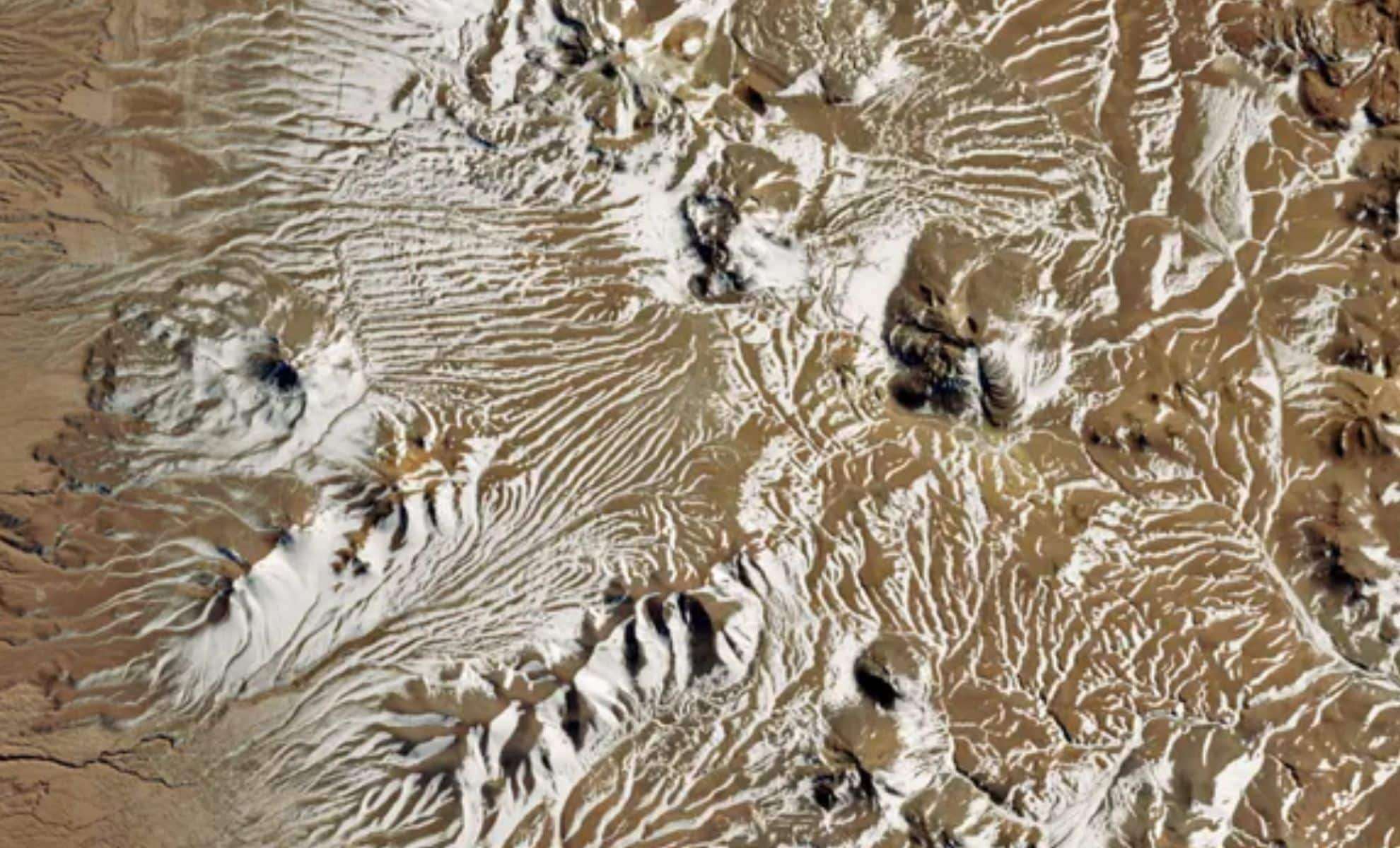
On June 25, 2025, a remarkable phenomenon took place over the Atacama Desert, renowned as the driest desert on the planet. Snowfall, an exceptional occurrence for this region, blanketed the terrain for the first time in over ten years, as confirmed by meteorologists. NASA’s Terra satellite captured a breathtaking image of this snow-covered expanse, showcasing the high-altitude areas of the Atacama, including both the Altiplano and the Chajnantor Plateau. This rare event has intrigued scientists, especially given the desert's position in the rain shadow of the Chilean Andes. The sudden arrival of snow brought moisture to this typically arid environment, sparking widespread fascination with the unusual weather shift.
Why Is the Atacama Desert So Exceptionally Dry?
Situated between the Andes Mountains and Chile's Pacific coastline, the Atacama Desert is widely recognized as the most arid place on Earth. Its extreme dryness results from multiple factors, primarily the rain shadow effect from the towering Andes. As moist ocean air ascends the mountains, it cools, shedding most of its moisture as rain or snow. By the time this air descends into the Atacama, it’s nearly depleted of moisture, creating the desert’s famously barren landscape.
Additionally, the cold Humboldt Current flowing northward along Chile’s coast inhibits cloud formation and rainfall. This current contributes significantly to the desert’s persistent drought, making any incoming moisture, such as the recent snow, a rare and noteworthy event.

Effects of the Snow on Key Scientific Observatories
Beyond altering the landscape, the snowstorm had immediate consequences for research facilities in the Atacama. The desert houses several world-class observatories, including the Atacama Large Millimeter/submillimeter Array (ALMA) and the Southern Astrophysical Research (SOAR) Telescope, both pivotal for advancing our understanding of the cosmos, especially radio astronomy.
While the SOAR telescope at higher altitude experienced only light snow, ALMA, situated lower, encountered substantial snowfall. This accumulation triggered protective measures that temporarily suspended scientific observations. The incident underscores the sensitivity of advanced instruments to rare environmental phenomena, highlighting how even exceptional weather can disrupt cutting-edge astronomy.
Decoding the Weather System Behind the Unexpected Snow
This unusual snowfall was driven by a cold-core cyclone moving into the normally dry region. These low-pressure systems can induce precipitation, including snow, in areas that rarely see such weather. Although uncommon in the Atacama, meteorologists note that these cyclones can occasionally develop under specific atmospheric conditions.
Cold-core cyclones generate significant cooling, leading moisture in the air to condense and fall as snow. The presence of such a storm in the Atacama points to the increasingly dynamic and variable nature of global weather patterns, possibly influenced by climate change. While infrequent, this snow event serves as a reminder that extreme and surprising weather can affect even the planet’s driest regions.
NASA Satellites Track Extraordinary Weather Events on Earth
The snowstorm was observed via NASA’s MODIS (Moderate Resolution Imaging Spectroradiometer) aboard the Terra satellite, which monitors Earth’s surface from orbit. MODIS provides vital real-time data on weather, vegetation, and land temperatures. The satellite imagery revealed a striking contrast between the snow-covered desert and its usual arid terrain, delivering crucial insights into the storm’s impact.
Instruments like MODIS aboard Terra are key tools for scientists studying extreme meteorological events and longer-term climate trends. Their data aid in understanding how global warming alters precipitation, temperatures, and the frequency of rare phenomena such as this snowfall over the Atacama Desert.
- Categories:
- News


0 comments
Sign in to Comment