
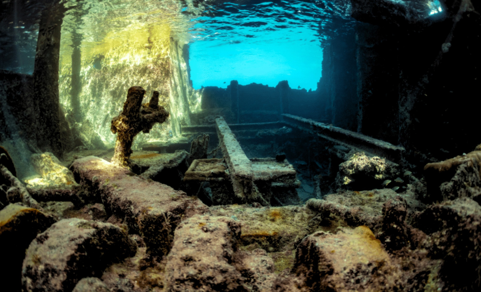
Below the surface of a reservoir in southeastern Turkey, ancient stone walls, a mosque, an arched bathhouse, and a series of rock-carved tombs have lain hidden for nearly 30 years. Recent underwater footage obtained during a training dive has unveiled a perfectly preserved settlement beneath Dicle Dam Lake in the Eğil district of Diyarbakır.
This underwater cityscape features a mosque, a religious school, extensive cemeteries, rock-cut tombs, and the Byzantine-era Deran Bath. Professor İrfan Yıldız, Dean of the Faculty of Arts and Design at Dicle University, carefully examined the footage and verified that these buildings remain structurally sound despite the decades spent underwater.
“The images captured by the teams and visible when water levels drop show that these historical structures have maintained their integrity and continue to stand firmly,” Yıldız stated, as reported by HeritageDaily.

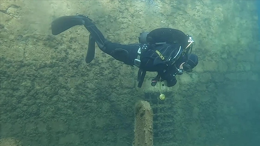
The remarkable footage was captured by gendarmerie search and rescue divers during a recent training drill, according to Hürriyet Daily News. As their cameras scanned the submerged settlement, they confirmed earlier rumors and occasional exposure during droughts. Far from being destroyed, the reservoir had effectively encased the ancient neighborhood.
A Convergence of Civilizations
Situated some 52 kilometers from Diyarbakır’s center, Eğil has been continuously inhabited for millennia. Civilizations including the Hurri-Mitanni, Assyrians, Urartians, Persians, Romans, and Byzantines traversed this vital corridor well before Islamic governance took hold in the 7th century.
The valley’s cliffs still bear inscriptions and rock-cut tombs from past rulers who took advantage of the commanding high ground for defense and prestige. Successive empires added their marks over centuries. Ottoman-era mosques and educational institutions eventually stood alongside burial sites dating back to ancient times.
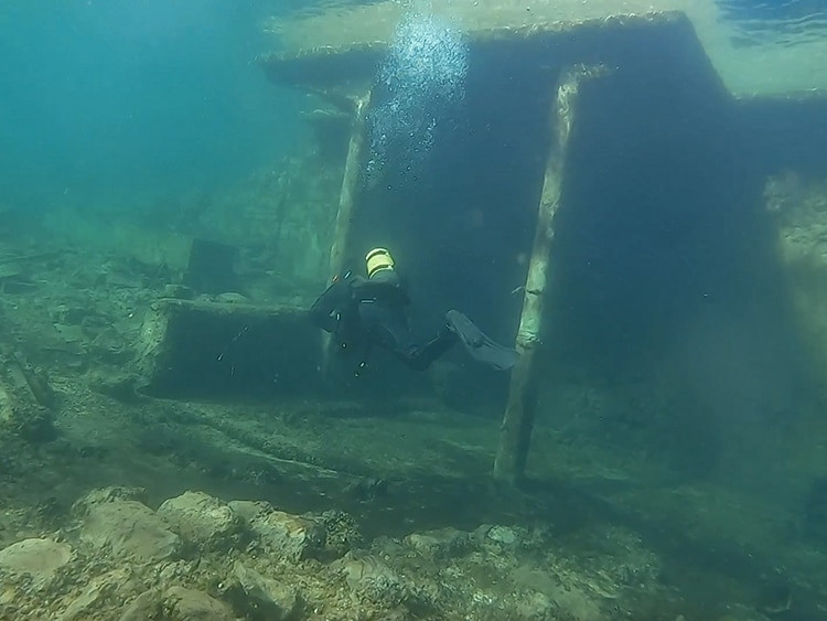
The submerged ruins are relatively younger but remain embedded within this prolonged cultural narrative. The mosque, madrasa, and accompanying cemetery formed an integrated community hub where worship, learning, and memorialization occurred together. The bathhouse occupied a key position on the daily route connecting sacred sites to the hillside.
The construction of the dam began in 1986, becoming operational in 1997. As the reservoir filled, entire neighborhoods such as Tekke and Hacıyan, along with their historic features, were submerged. Tombs related to prophets Zulkifl and Elyesa were relocated to higher ground in 1995, while many other structures were left beneath the rising waters.
Insights From the Dive Footage
The dive footage reveals a well-preserved complex: a tomb near a mosque, a religious school adjoining a cemetery, and the Deran Bath intact along a submerged pathway. The spatial layout indicates a functional settlement rather than a random collection of ruins.
According to Yıldız, whose study was published via Dicle University, the arrangement aligns with historical records of these drowned districts. Key features such as walls, courtyards, and connecting paths remain distinguishable. The calm underwater environment and absence of human interference have protected the stonework from usual erosion processes.
Noteworthy elements visible include the Prophet Elisha tomb and mosque complex and the Caferiye Madrasa, also known as Lala Kasım Madrasa, dating back to the Ottoman period. Extensive cemeteries spread around these sites.
The underwater footage covers only a portion of the site, with sediment accumulation, depth, and limited accessibility concealing much of the rest. No comprehensive map exists yet, while the condition of unfilmed structures is uncertain. Water levels fluctuate, intermittently exposing and submerging masonry, stirring silt, and potentially damaging fragile sections.
A Call for Comprehensive Exploration
Yıldız has urged the initiation of formal underwater archaeological research to move beyond incidental observations and establish a systematic record of the site.
“Underwater archaeological studies can be carried out on these remains,” he said.
Such a survey would provide detailed documentation of remaining structural integrity, erosion areas, and sections that require urgent preservation measures. It would also uncover original building materials, architectural techniques, and the overall urban design of the settlement. Without this effort, the site risks being gradually lost.
The reservoir presents challenges for research, including restricted access for safety, sudden drops in visibility, and silt that can conceal features between inspections. Researchers would need to combine underwater imaging, mapping, and local oral histories to create an accurate and lasting record before further deterioration.
During dry seasons, lower water levels briefly reveal parts of the sunken town. Exposed walls and gravestones allow local residents to reconnect with this ancient landscape and the modern shoreline, confirming the endurance of these historical treasures even as they risk fading again beneath the water.
The Dicle Dam Lake plays a vital role in supplying water for the region, yet its creation altered the Tigris River valley profoundly, displacing communities and submerging centuries of cultural heritage beneath its surface.
- Categories:
- Science


0 comments
Sign in to Comment