
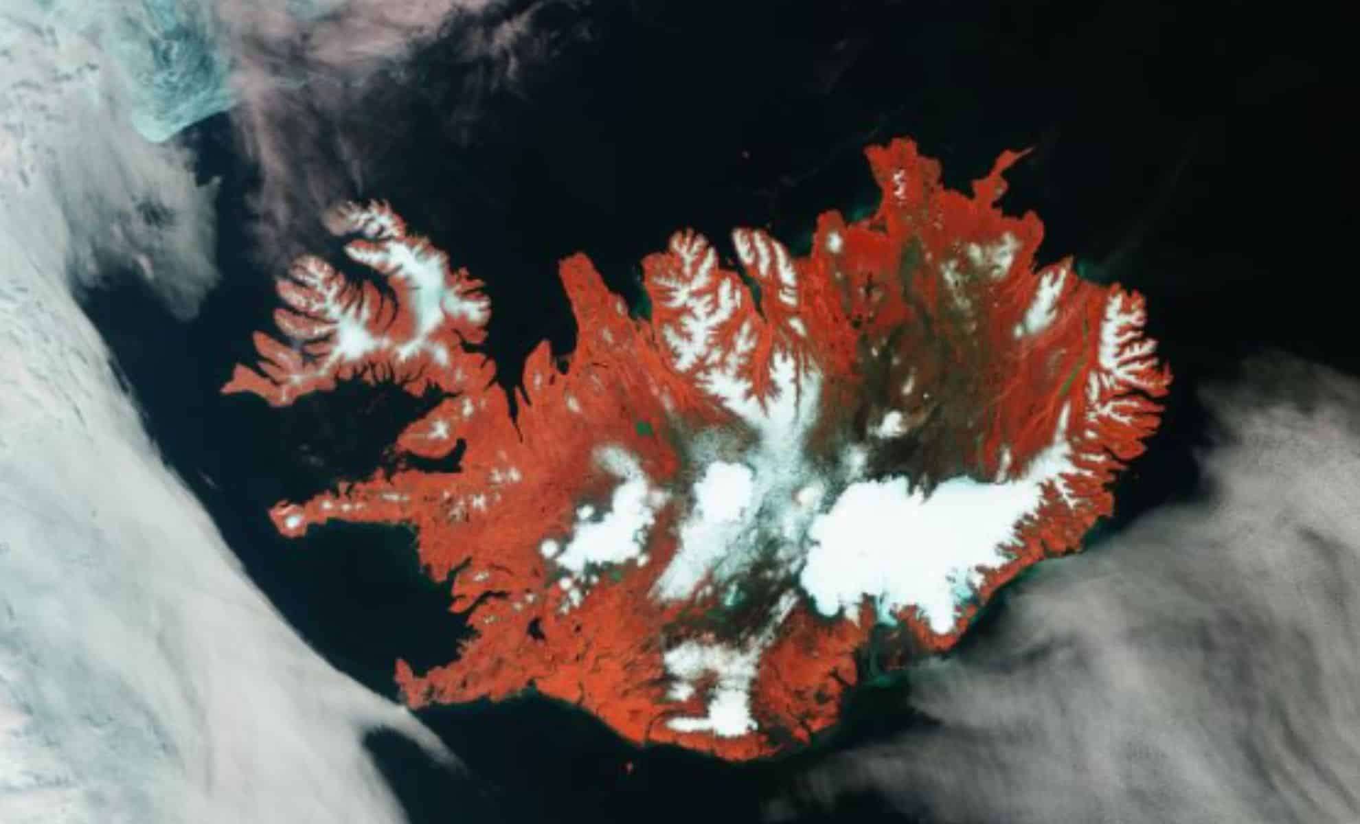
On May 17, 2025, the European Space Agency (ESA) unveiled a remarkable satellite snapshot of Iceland, taken during an extraordinary cloudless interval by the Copernicus Sentinel-3 mission. Renowned for its dramatic contrasts of fire and ice, this island is now revealed in stunning detail through sophisticated false-color imaging. Captured amidst an intense May heatwave, this image serves not only as visual documentation but also as vital scientific data for analyzing glacier boundaries and surface heat variations in the area.
Iceland’s Dramatic Landscape: Icefields, Volcanoes, and Lava Expanses
Utilizing the near-infrared capabilities of Sentinel-3’s Ocean and Land Colour Instrument (OLCI), the image presents Iceland’s terrain in a unique spectrum beyond human vision. Vegetation appears as vibrant reds, distinctly separated from brown volcanic rock and barren lava stretches. Dark sections mark newly formed lava flows, while white regions represent snow and glaciers primarily situated in the east.

Sentinel-3’s Infrared Imaging Unlocks Insights Beyond Aesthetics
The true strength of this image lies in its enhanced color contrasts that provide deeper scientific insights. The OLCI sensor utilizes infrared wavelengths to clearly differentiate between vegetation, soil, and rocky areas—details that standard visible-light images often obscure. These distinctions are crucial for assessing habitat conditions, land management, and monitoring volcanic phenomena.
The rich green shades visible along rivers and lakes result from mineral-laden sediments. Meltwater from glaciers carries these sediments into the surrounding North Atlantic Ocean. Coastal waters around Iceland display a vivid green hue, serving as a natural indicator for researchers studying glacial meltwater discharge and erosion.
Near the island’s northwest margin, close to Greenland’s shoreline, patches of light blue reveal drifting fragments of sea ice. Propelled by prevailing winds and ocean currents, these ice floes add further complexity to the dynamic seascape.
Captured During a Record-Breaking May Heatwave
The timing of the Sentinel-3 overpass adds profound importance to this observation. The data was gathered during a severe heatwave from May 13 to May 22, 2025, marked by unusually high temperatures and dry atmospheric conditions. Alongside the imagery, Sentinel-3’s Sea and Land Surface Temperature Radiometer (SLSTR) collected surface temperature measurements that contribute to ongoing climate research.
This rare clear-sky interval allowed the satellite to deliver both comprehensive visuals and crucial thermal data that may highlight increasing rates of glacier retreat and drying soil surfaces. Researchers worry that the growing frequency of these extreme weather events reflects long-term shifts in climate behavior across one of Earth's most vulnerable environments.
- Categories:
- News


0 comments
Sign in to Comment