

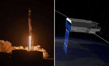
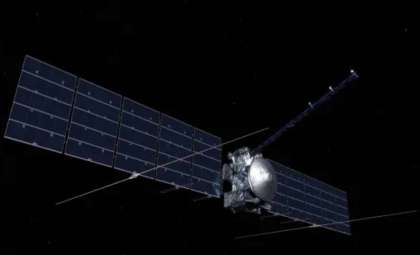
Marking a pivotal advancement in Earth observation technology, the NASA-ISRO Synthetic Aperture Radar (NISAR) mission has successfully deployed its enormous 33-foot radar antenna reflector in space. According to NASA’s Jet Propulsion Laboratory, this major achievement completes the extension of a critical instrument aboard the collaborative US-India satellite, opening new possibilities for worldwide environmental surveillance. The deployment of the umbrella-like reflector—now the most expansive antenna reflector ever launched on a NASA Earth science mission—enables detailed radar imaging of our planet’s surface to support global infrastructure resilience, agricultural sustainability, and disaster management.
Transforming Earth Science Research
The successful unfolding of this radar reflector signifies a monumental step forward in remote Earth sensing. Positioned approximately 460 miles above the Earth, NISAR employs dual-frequency L- and S-band synthetic aperture radar to capture Earth's surface in extraordinary detail. This radar technology can penetrate cloud cover and operate continuously, delivering reliable data regardless of atmospheric or lighting conditions.
NASA Headquarters’ Earth Science Division director Karen St. Germain highlighted the significance of this development:

“The successful deployment of NISAR’s reflector marks a significant milestone in the capabilities of the satellite. From innovative technology to research and modeling to delivering science to help inform decisions, the data NISAR is poised to gather will have a major impact on how global communities and stakeholders improve infrastructure, prepare for and recover from natural disasters, and maintain food security.”
Featuring a 39-foot aperture, the reflector is compacted into a container just 7.9 feet wide and 2.6 feet tall for launch and then unfolds into a sophisticated structure once in orbit. Its impressive size facilitates enhanced resolution to detect changes on Earth’s surface globally, from shifting glaciers and seismic fault lines to agricultural patterns.

Crafting a Giant Above Earth
The antenna reflector is the product of an extensive international partnership and years of engineering. Constructed by Astro Aerospace, a subsidiary of Northrop Grumman, it underwent rigorous pre-flight testing. The impressive accomplishment reflects the collaborative efforts of Jet Propulsion Laboratory (JPL) and ISRO, jointly overseeing the NISAR project.
Phil Barela, NISAR’s project manager from JPL, highlighted the reflector's critical role:
“This is the largest antenna reflector ever deployed for a NASA mission, and we were of course eager to see the deployment go well. It’s a critical part of the NISAR Earth science mission and has taken years to design, develop, and test to be ready for this big day. Now that we’ve launched, we are focusing on fine-tuning it to begin delivering transformative science by late fall of this year.”
Engineers faced immense challenges ensuring the antenna’s resilience through launch, survival in the vacuum of space, and stable operation while spinning at roughly 4.5 rotations per minute to scan Earth’s surface. These factors demanded precise engineering and careful calibration.
How Synthetic Aperture Radar Reveals Hidden Details
At the heart of the mission, synthetic aperture radar (SAR) technology provides detailed and large-scale Earth imaging. By leveraging the satellite's motion, SAR effectively replicates a far larger antenna than physically possible, achieving remarkable image clarity.
Paul Rosen, the JPL project scientist for NISAR, explained:
“Synthetic aperture radar, in principle, works like the lens of a camera, which focuses light to make a sharp image. The size of the lens, called the aperture, determines the sharpness of the image. Without SAR, spaceborne radars could generate data, but the resolution would be too rough to be useful. With SAR, NISAR will be able to generate high-resolution imagery. Using special interferometric techniques that compare images over time, NISAR enables researchers and data users to create 3D movies of changes happening on Earth’s surface.”
These 3D visualizations are not only visually striking but offer crucial scientific insights. They allow monitoring of urban subsidence, early warning of natural disasters such as landslides and volcanic eruptions, and evaluation of climate change effects on glaciers and forests. This continuous monitoring of subtle surface shifts is one of NISAR’s most significant contributions.
Empowering Global Decision-Making
NISAR's mission extends beyond scientific research to aid policy makers, urban planners, and disaster relief groups. The data outputs will assist in climate adaptation, emergency preparedness, and crafting environmental strategies worldwide. By tracking agricultural cycles and land use, it supports enhanced food security efforts. Its capacity to detect ground deformation can also alert authorities to impending geological threats.
Thanks to its open access data policy, NISAR’s findings will be freely available to spur innovation and foster global cooperation. The satellite will cover Earth’s surface every 12 days, making previously undetectable gradual changes visible, offering insight with long-term impact.
- Categories:
- News


0 comments
Sign in to Comment