
New investigations, highlighted by a pivotal study featured in the Journal of Geophysical Research, have revealed a fascinating development in South Africa, where land is gradually ascending from the ocean. Previously, scientists attributed this uplift to shifts within the Earth’s interior, particularly geodynamic forces beneath the crust. However, recent evidence proposes that extensive drought-related water loss might be the main factor behind this rising movement.
Traditionally, researchers considered the cause of elevation increase to be linked to mantle flow, such as an upwelling plume exerting pressure from the planet’s depths. Yet, this newly published work suggests that drought-driven dehydration of the landscape may instead be the dominant influence causing this steady land rise.
A Fresh Approach to Explaining Land Elevations
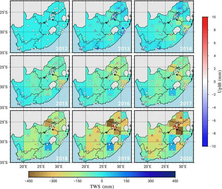
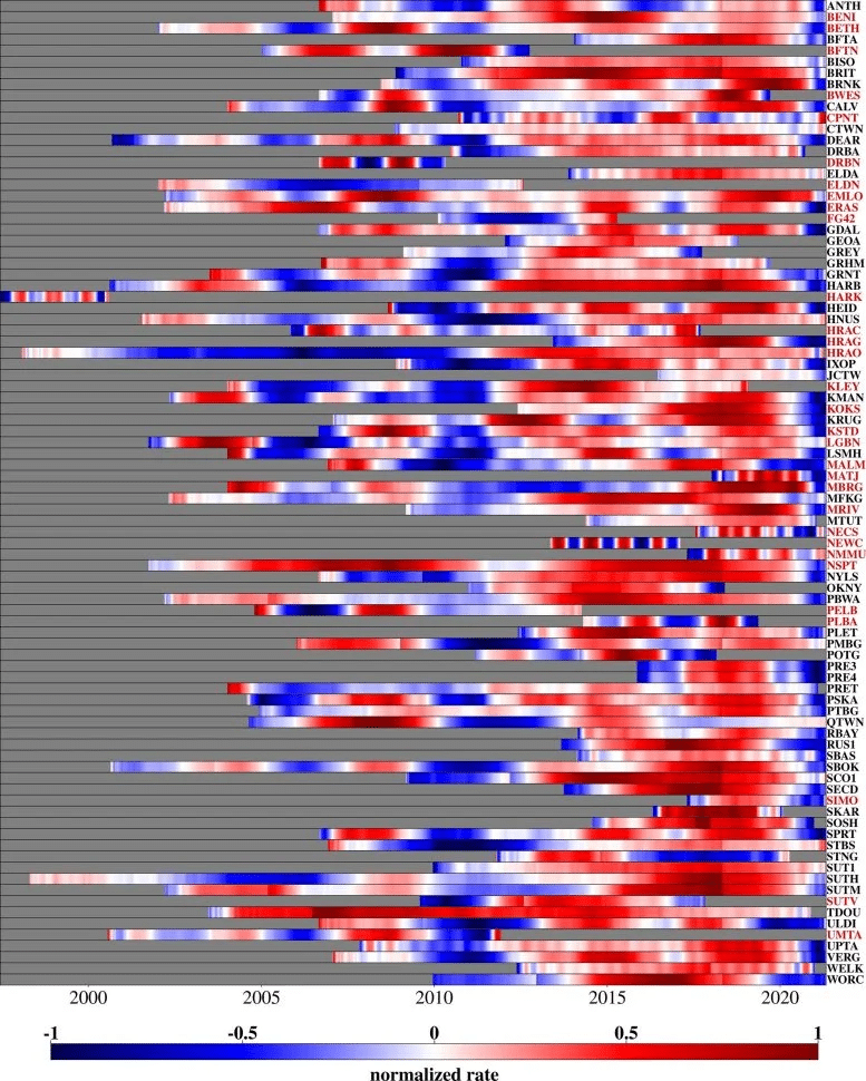
South Africa has shown a slow but measurable elevation increase, with some locales climbing up to two millimeters annually. From 2012 to 2020, this vertical shift was especially significant, as data collected by permanent GPS stations nationwide enabled highly accurate tracking of subtle land height changes. These stations, integrated into an extensive system monitoring both horizontal and vertical ground movements, have offered key insights into the geological dynamics at play.

“Our measurements showed an average elevation gain of six millimeters between 2012 and 2020,” reports Dr. Makan Karegar from the Institute of Geodesy and Geoinformation at the University of Bonn. Positioned within the institution’s Sustainable Futures research program, Dr. Karegar points out that these findings have transformed the scientific understanding of what drives this uplifting phenomenon.
While initial theories focused on mantle convection — where heated material ascends beneath the Earth’s crust — creating surface bulging, the University of Bonn team explored an alternative cause tied to drought conditions.
Integrating Satellite and GPS Observations to Understand the Phenomenon
To validate their theory, researchers analyzed data from permanent GPS networks alongside data from the GRACE satellite mission, which measures gravitational anomalies corresponding to variations in water mass across the landscape. These satellites can quantify changes in surface water, groundwater, and soil moisture levels.
The analysis yielded compelling results. “This approach allows us to estimate shifts in total water mass, encompassing surface water, soil moisture, and groundwater,” explains Christian Mielke, a scientist at the Institute of Geodesy and Geoinformation. He notes, however, that GRACE data's spatial resolution is limited to several hundred kilometers, which restricts its ability to detect finer-scale local changes.
The combined GPS and satellite observations indicated the most significant rises occurred in areas heavily affected by drought. As regional water reservoirs dried, the Earth’s crust experienced a rebound effect, akin to a foam ball regaining shape after pressure is removed.
Mechanics Behind the Rising Ground
The key scientific principle at work is elastic rebound. When water is depleted from the land’s surface—whether groundwater, soil moisture, or surface water—the downward pressure these volumes exert decreases. This reduction allows the Earth’s crust to expand upward, much like releasing pressure on a compressed foam ball enables it to bounce back.
Dr. Karegar elaborates, “Our tests have revealed that groundwater and surface water loss due to drought may substantially contribute to land elevation gain.” The correlation between drought severity and uplift magnitude is becoming more evident, with the most dramatic surface rise noted during the intense 2015-2019 drought period, which nearly caused Cape Town to reach a critical water shortage milestone known as “day zero.”
Implications for Monitoring and Managing Water Resources
This innovative study not only advances understanding of drought-related geological changes but also introduces a new approach for managing water resources in vulnerable regions. Beyond interpreting land movements, it provides a novel method to track groundwater depletion. Monitoring earth elevation changes via GPS can offer scientists an indirect measurement of how much water reserves have diminished over time.
South Africa’s case suggests that using land rise as a proxy for water loss may be an efficient, low-cost technique for assessing the status of critical water supplies. As climate change alters precipitation patterns and heightens drought risk worldwide, this method could be pivotal in crafting smarter water conservation policies to protect essential freshwater resources.
Recognizing the link between drought and terrain uplift could become an essential tool for managing water scarcity. In regions prone to extended dry periods, such monitoring could alert authorities to groundwater exhaustion, facilitating timely interventions to safeguard this vital resource.
- Categories:
- News


0 comments
Sign in to Comment