

Since its 2018 launch, NASA’s ICESat-2 spacecraft has accomplished a remarkable feat, emitting 2 trillion laser pulses from orbit. This cutting-edge mission delivers unmatched data on the planet’s melting ice caps, glaciers, forests, and ocean floors.
The satellite's high-precision laser system, ATLAS (Advanced Topographic Laser Altimeter System), remains fully operational and may extend its vital observations well into the 2030s.
Tracking Ice Dynamics Through Laser Pulses
On March 9, 2025, at exactly 12:51 p.m. EDT (16:51 UTC), ICESat-2 emitted its 2 trillionth laser pulse while scanning cloud formations over East Antarctica. Designed to measure ice surface elevation, the satellite monitors both the Antarctic and Greenland ice sheets, revealing crucial data on changing ice mass.
By launching approximately 10,000 pulses each second, ICESat-2 constructs detailed three-dimensional maps of the Earth’s surface, especially valuable in polar regions for climate science.

Enduring Laser Technology Delivering Long-Term Data
Findings from a European Geosciences Union publication confirm that the ATLAS instrument is still operating at peak efficiency after six years and trillions of pulses.
Anthony Martino, research scientist at NASA’s Goddard Space Flight Center, affirms there is no evidence of laser degradation. Should this resilience continue, the mission might persist into the 2030s, supported by a backup laser system to ensure continuity.
Besides monitoring ice, ICESat-2’s laser gathers data on forests, lakes, and even sections of the seafloor, helping scientists track reservoir fluctuations, glacier movements, and coastal underwater terrain.
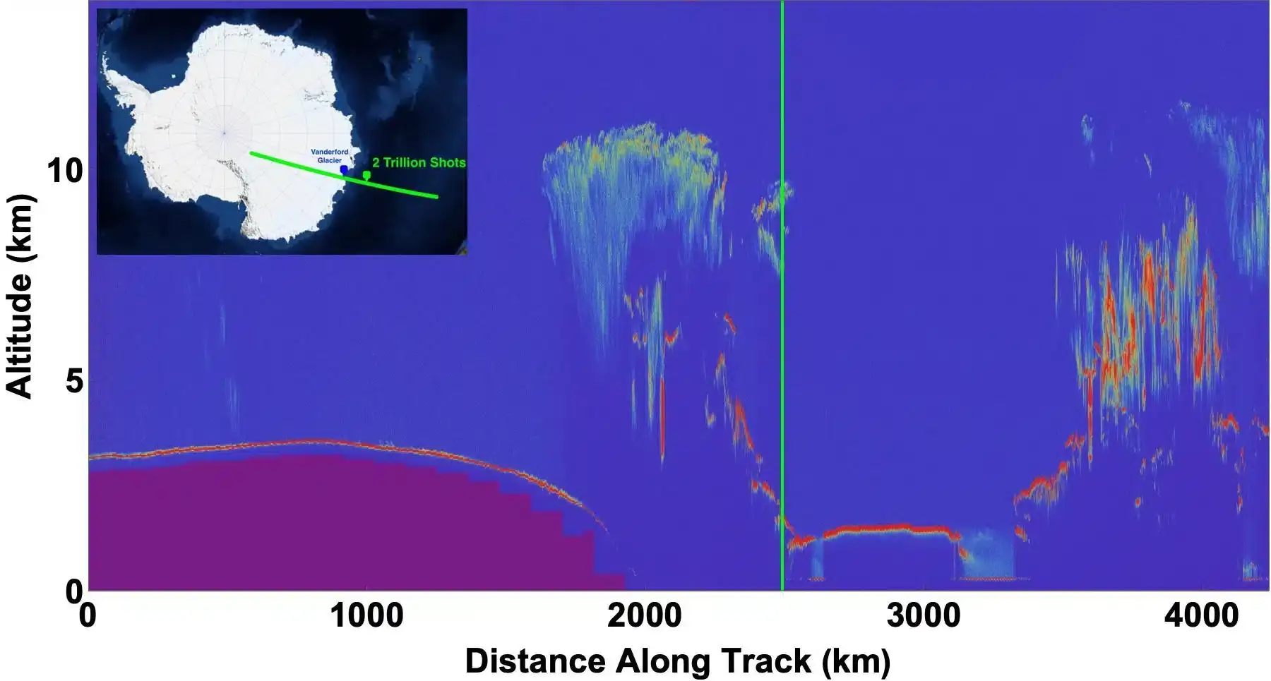
Vanderford Glacier: Insight into Accelerating Ice Loss
ICESat-2 data has uncovered dramatic changes at the Vanderford Glacier, among East Antarctica’s fastest ice retreats. Warmer ocean currents beneath are hastening ice melt.
Monitoring a location on Vanderford from 2019 to 2022, ICESat-2 observed a six-foot decline in surface ice height. Although a brief recovery happened in 2023, ice levels dropped again in 2024, indicating ongoing instability.
Unlocking Earth’s Ice History With Trillions of Pulses
Having fired 2 trillion laser pulses, ICESat-2 has constructed a detailed global archive of ice surface changes. These precise measurements, both broad and high-resolution, support accurate predictions of sea-level rise and deeper understanding of climate impacts.
Deputy project scientist Denis Felikson highlights the mission’s value: “The data from 2 trillion laser pulses provide a consistent, global perspective of Earth’s ice, combining broad glacier-scale views with intricate details essential to tracking planetary changes over time.”
Beyond Icy Landscapes
ICESat-2’s laser capabilities extend well beyond polar ice. It also quantifies forest canopy heights for carbon assessment, monitors inland water levels related to droughts, and maps coastal and deep-ocean floors, revealing previously hidden underwater features. Additionally, it observes atmospheric phenomena like clouds and particles, enriching climate models and weather forecasts.
With groundbreaking discoveries expected ahead, ICESat-2’s mission is far from complete. The milestone of firing its 2 trillionth laser pulse represents a significant step in what promises to be years of invaluable Earth observation.
- Categories:
- Science


0 comments
Sign in to Comment