
In December 2024, advanced satellites documented an incredible oceanic event—waves towering nearly 66 feet high. Occurring during Storm Eddie, these colossal waves set a new record for the tallest ocean swells ever observed from orbit. By analyzing data from cutting-edge satellite instruments, scientists are gaining new insights into the dynamics of massive storm-generated waves traveling across the seas.
Storm Eddie’s Surprising Fury
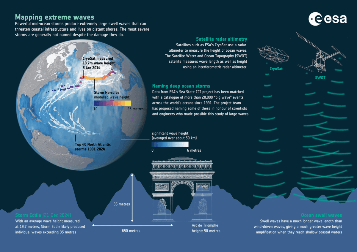
On December 21, 2024, Storm Eddie unleashed enormous waves across the North Pacific Ocean. Satellites such as Copernicus Sentinel-6 and SWOT (Surface Water and Ocean Topography) captured these waves reaching heights of up to 66 feet, establishing an unprecedented space-based measurement of average wave height. These observations, supported by years of satellite monitoring, highlight the powerful capabilities of modern remote sensing to analyze ocean conditions with remarkable precision. According to the European Space Agency (ESA), such data are crucial for comprehending the impacts of large ocean storms on marine habitats and coastal environments located far from where the storms originate.
These vast waves are not merely spectacular—they convey essential clues about the intensity, scale, and progression of the storm. Unlike the brief, choppy waves near shorelines, ocean swells can carry their energy across thousands of miles for days or even weeks. Once underestimated as just large ripples, the detailed study of these swells is unveiling how they influence oceanic systems on a global scale, even when the storm itself remains distant from land.

Delving into Ocean Swell Energy
Ocean swells originate from strong winds during storms but are distinguished by their impressive ability to retain energy over vast distances. These swells essentially carry a snapshot of the originating storm’s magnitude and vigor across the sea.
“At the coast, seabed conditions also shape waves, for example, and these very large storms are rare – occurring roughly once a decade – which makes it hard to prove trends,” said Fabrice Ardhuin, a scientist at the Laboratory of Physical and Spatial Oceanography in France, who led the study.
The prolonged movement of these swells can profoundly influence coastal erosion and the durability of maritime structures, even when the storm has moved well beyond visible reach.
A key revelation from this research is how wave energy disperses. Previously, it was assumed that the longest ocean waves transported most of the energy during travel. However, new satellite observations demonstrate that the storm’s primary peak waves, rather than the longest swells, contain the majority of the wave energy. This insight is vital for enhancing predictions related to storm damage, coastal defense, and maritime safety. By tracing wave energy distribution, scientists are better equipped to understand and mitigate the lingering effects of storms on coastal areas.
Epic Voyage Across Oceans
The epic scale of the waves’ journey further highlights their significance. Storm Eddie’s swells traversed more than 15,000 miles over 15 days, passing from the North Pacific, through the Drake Passage near Antarctica, all the way to the tropical Atlantic by early January 2025. This extensive travel is not merely a demonstration of nature’s might but also a vital component of Earth's climate mechanisms. As these waves propagate, they interact with ocean currents and atmospheric winds, offering valuable, real-time insights into evolving environmental patterns.
Such wide-ranging measurements were achieved thanks to an array of sophisticated satellite instruments, including SWOT’s broad radar swath and the dual-frequency radar altimeter aboard Sentinel-6. These technologies have greatly advanced our capacity to not only measure wave height but also quantify their length, energy, and frequency. Continued missions like SWOT promise to deepen our understanding of massive ocean swells, leading to more accurate forecasting and enhanced global awareness.
Linking Waves to Climate Shifts
The influence of climate change on the frequency and strength of ocean storms remains an active field of investigation. While it’s widely speculated that rising global temperatures amplify extreme weather, conclusively demonstrating these patterns is challenging.
“Climate change may be a driver, but it is not the only one,” said Fabrice Ardhuin. “At the coast, seabed conditions also shape waves, for example, and these very large storms are rare – occurring roughly once a decade – which makes it hard to prove trends.”
The infrequency of severe waves, appearing about once every ten years, complicates efforts to definitively connect them to climate change.
Despite these difficulties, the recent breakthroughs highlight how satellite technology can monitor long-term shifts in storm dynamics. By combining historic records with up-to-date satellite data, researchers are starting to identify evolving trends in storm magnitude and wave strength. These advancements are crucial for anticipating future ocean conditions and protecting coastal communities and infrastructure from increasingly unpredictable weather phenomena.
- Categories:
- News


0 comments
Sign in to Comment