

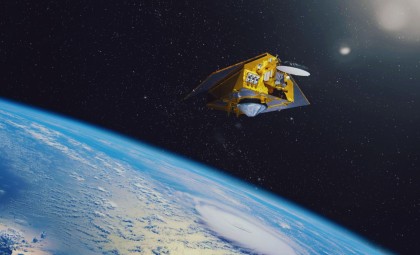
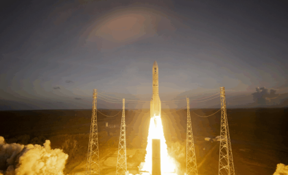
The European Space Agency (ESA) has made a pivotal advancement in environmental science with the launch of its HydroGNSS mission. Deployed on November 28, 2025, this mission is set to deepen insights into Earth's water resources and track the effects of climate change on global water dynamics. The project harnesses cutting-edge satellite techniques centered on Global Navigation Satellite System (GNSS) reflectometry to detect and analyze water bodies.
HydroGNSS: ESA's Innovative Approach to Tracking Water and Climate Patterns
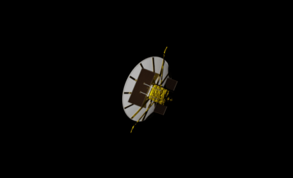
ESA’s HydroGNSS mission represents the first spacecraft launched under ESA’s Scout initiative, which features compact and cost-efficient Earth observation satellites. Utilizing GNSS reflectometry—a method that gathers and interprets satellite signals bounced off the planet’s surface—this technology allows HydroGNSS satellites to monitor critical water-related parameters like soil moisture, flooding, and vegetation density.
ESA’s Director of Earth Observation Programmes, Simonetta Cheli, emphasized the mission's significance:

“As the first of ESA’s Scout missions to launch, HydroGNSS marks an important milestone for this new family of rapid, low-cost Earth observation missions, and we extend our thanks to the mission’s prime contractor, SSTL.”
The Scout program’s quick development cycle and budget-friendly design align with ESA’s broader objective to develop innovative solutions for pressing global environmental challenges.
HydroGNSS will offer timely, high-detail environmental data that can enhance forecasting methods and inform climate adaptation strategies. Its capability to capture water cycle indicators, such as soil moisture and freeze-thaw transitions, provides crucial insights for scientists and policy makers focused on mitigating climate change impacts.
This mission’s data will also be instrumental in enhancing flood forecasting, improving early warning systems, and helping communities prepare for natural disasters.
Revolutionizing Earth Observation Through GNSS Reflectometry
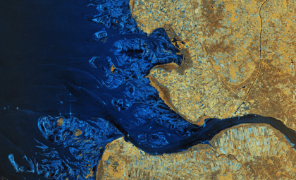
The HydroGNSS satellites apply GNSS reflectometry, a sophisticated approach that utilizes L-band signals transmitted by GNSS constellations including GPS and Galileo. By collecting signals reflected off the Earth’s surface alongside direct signals, the satellites generate detailed maps of water-related features such as soil moisture, vegetation, and water levels. The analysis of these reflected signals unlocks new perspectives on surface characteristics vital for comprehending the water cycle and its changes due to climate pressures.
Each HydroGNSS satellite houses a delay Doppler mapping receiver equipped with two antennas—one to track direct GNSS transmissions and another to capture reflections. These combined signals are processed into precise environmental datasets, enabling continuous and accurate monitoring of hydrological conditions, including droughts and floods.
This approach offers a more economical and scalable alternative to traditional Earth observation techniques by utilizing existing satellite signals for data collection. Small and efficient, HydroGNSS satellites contribute invaluable information to sectors like agriculture, natural resource management, and emergency response.
Enhancing Climate Change Insight with HydroGNSS
A central ambition of the HydroGNSS mission is to delineate how climate change transforms water distribution and dynamics globally. Climate alterations impact water resources profoundly, influencing rainfall, drought incidence, and flood frequency. Monitoring soil moisture and freeze-thaw dynamics in near real-time allows scientists to observe and analyze these changing patterns intensively.
Furthermore, HydroGNSS offers critical data on wetlands, ecosystems essential for regulating the global carbon cycle and mitigating climate effects. Typically remote and difficult to survey, wetlands can now be monitored through satellite detection of waterlogged and inundated zones. As significant sources of methane emissions, tracking wetlands aids in climate change mitigation. Additionally, understanding permafrost behavior in polar regions through freeze-thaw mapping adds valuable knowledge where climate change poses substantial impacts.
ESA's Forward-Thinking Vision: Efficient and Agile Earth Monitoring
The HydroGNSS project embodies ESA’s commitment to next-generation Earth observation. Part of the FutureEO initiative, the Scout line focuses on delivering rapid, economical, and nimble satellite missions that complement the agency’s extensive Earth Explorer research projects. Developed and launched within just three years with a budget of €35 million, HydroGNSS illustrates how compact satellites can responsibly address urgent environmental issues affordably and promptly.
“The launch also represents a key step in the evolution of our FutureEO programme, where the Scouts embody a fast, agile, innovative and cost-efficient approach – complementing our larger Earth Explorer research missions,” said Simonetta Cheli. By blending rapid deployment with economical design, ESA’s Scout missions set new benchmarks for speedy and effective environmental monitoring in support of global sustainability.
- Categories:
- Space


0 comments
Sign in to Comment