
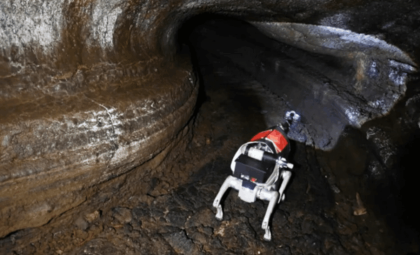
In the hills surrounding Rome's northern outskirts, an extraordinary discovery is reshaping our grasp of one of the early adversaries to the Roman Republic. Rather than traversing Martian landscapes, advanced robotics delved into narrow underground tunnels beneath the ancient Etruscan settlement of Veii, revealing an expansive system of sacred and water-management structures.
Known predominantly as a defeated foe—overcome by Rome in a fierce siege in 396 BC—Veii is now emerging as a remarkably sophisticated urban center, thanks to recent robotic-assisted archaeological endeavors. These efforts demonstrate that Veii’s legacy extends far beyond its conquest.
Under the guidance of the Museo Nazionale Etrusco di Villa Giulia and Sapienza University of Rome, in partnership with the Italian Ministry of Culture, scientists have finalized an unprecedented technological survey of Veii’s subterranean passageways. Findings point to a civilization with advanced capabilities in urban planning, water engineering, and ritualistic construction.

Unveiling the Hidden Underground Network
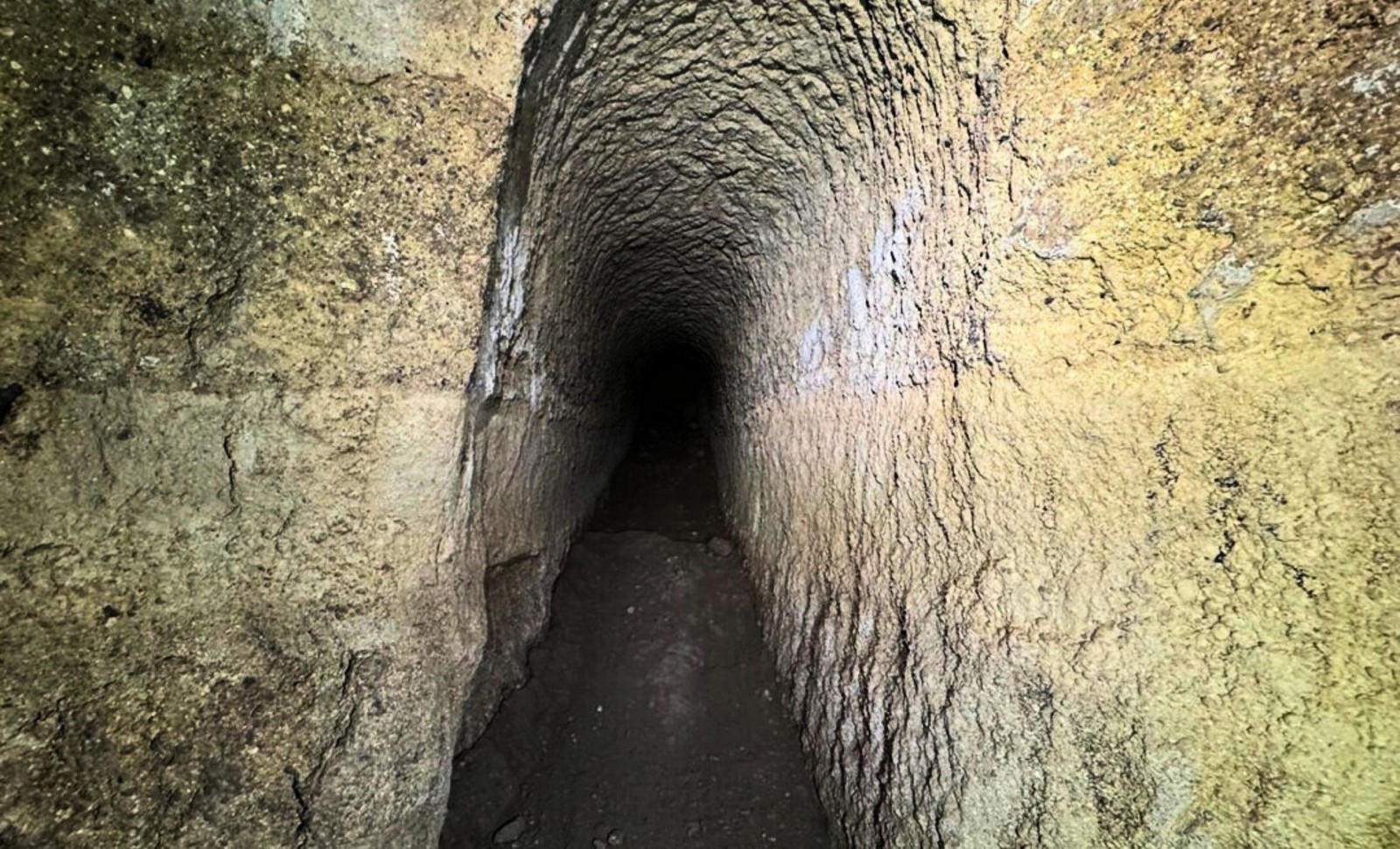
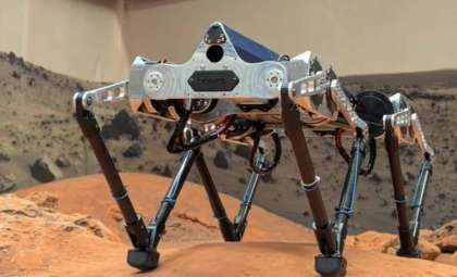
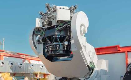
The autonomous rover, known as Magellano, utilizes a rocker-bogie suspension design—similar to that employed by NASA’s Mars rovers. However, Magellano’s mission diverged by exploring buried passages beneath Veii’s ruins, navigating collapsed and inaccessible cuniculi—subterranean channels historically used to control water flow and perhaps support ceremonial functions.
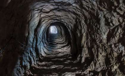
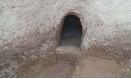
According to Arkeonews, these tunnels stretch beyond 23 kilometers, connecting sacred locations, defensive strongholds, and farming areas beneath the ancient cityscape. Among the standout discoveries is a 20-meter-wide ritual basin situated near the Apollo temple within the Sanctuary of Portonaccio. This pool likely served purification rites and was later adapted for Roman use.
By combining robotic exploration, digital mapping technologies, and non-invasive geophysical techniques, researchers have constructed a virtual model of underground environments too fragile or hazardous for traditional excavation. These strategies are setting new standards for archaeological investigations in sensitive locations worldwide.
Reevaluating an Etruscan Powerhouse
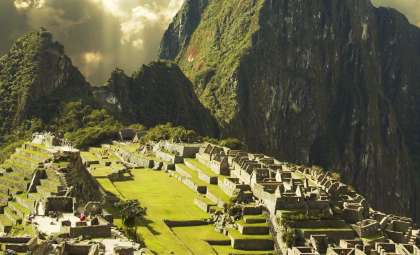
Situated only about 12 to 16 kilometers from early Rome’s core, Veii (in Latin) was a dominant force within the Etruscan League—a coalition of culturally linked city-states that influenced central Italy prior to Roman expansion.
Historical texts, especially writings by Livy, describe Veii’s downfall following a ten-year siege led by Marcus Furius Camillus. However, the new subterranean map challenges views of a straightforward collapse: the findings reveal a city engineered for sustained durability, incorporating engineered waterways and secret tunnels that likely served strategic and religious functions.
The scans confirm the tunnels’ construction was carefully planned, not random or solely utilitarian. Hydraulic channels interlink key urban sectors, indicating centralized design blending water supply with sacred sites. Elements such as reservoirs, wells, and multi-use conduits align precisely with major religious zones and urban limits.
The Sanctuary of Portonaccio, a principal religious complex in Etruria, sits atop this elaborate hydraulic framework. Water features were interconnected through discreet channels, reflecting a vision that combined ritual practices, water management, and architecture into a cohesive whole.
Advanced Space Technologies Illuminate Ancient Worlds
Originally crafted with space-grade navigation systems for extreme extraterrestrial terrains, the Magellano rover adapted these capabilities to terrestrial archaeological challenges. It maneuvered through unstable, claustrophobic underground routes, gathering data impossible for humans to access safely.
This project exemplifies a pioneering archaeological role for robotics and remote sensing, enabling detailed exploration in unreachable areas while protecting delicate heritage sites. The resulting comprehensive digital representation marks the first ever full-scale model of an Etruscan below-ground network.
Linking aqueduct infrastructures and surface landmarks such as the Campetti Plateau and the Cannetaccio Valley, the study highlights how Veii’s aboveground city life was deeply interconnected with its underground systems.
Researchers argue this degree of thoughtful urban design places Veii alongside globally renowned ancient cities celebrated for their complexity, including Petra, Teotihuacan, and select Mesopotamian centers.
Veii’s Enduring Influence and Unresolved Mysteries
Despite revealing impressive structural feats, this new mapping opens more questions. The Etruscans remain a somewhat enigmatic civilization—linguistically unique, spiritually mysterious, and often overshadowed by their Roman successors.
These tunnels offer fresh perspectives for examining Etruscan religious ceremonies and the geography of their sacred spaces. The alignment of water basins, conduits, and shrines encourages deeper analysis of their ritualistic worldview.
Most notably, the existence of these underground networks indicates an early form of urban resilience. Veii’s architects anticipated challenges, integrating subterranean infrastructure as a fundamental aspect of city life, effectively creating a multidimensional urban environment.
- Categories:
- News


0 comments
Sign in to Comment