
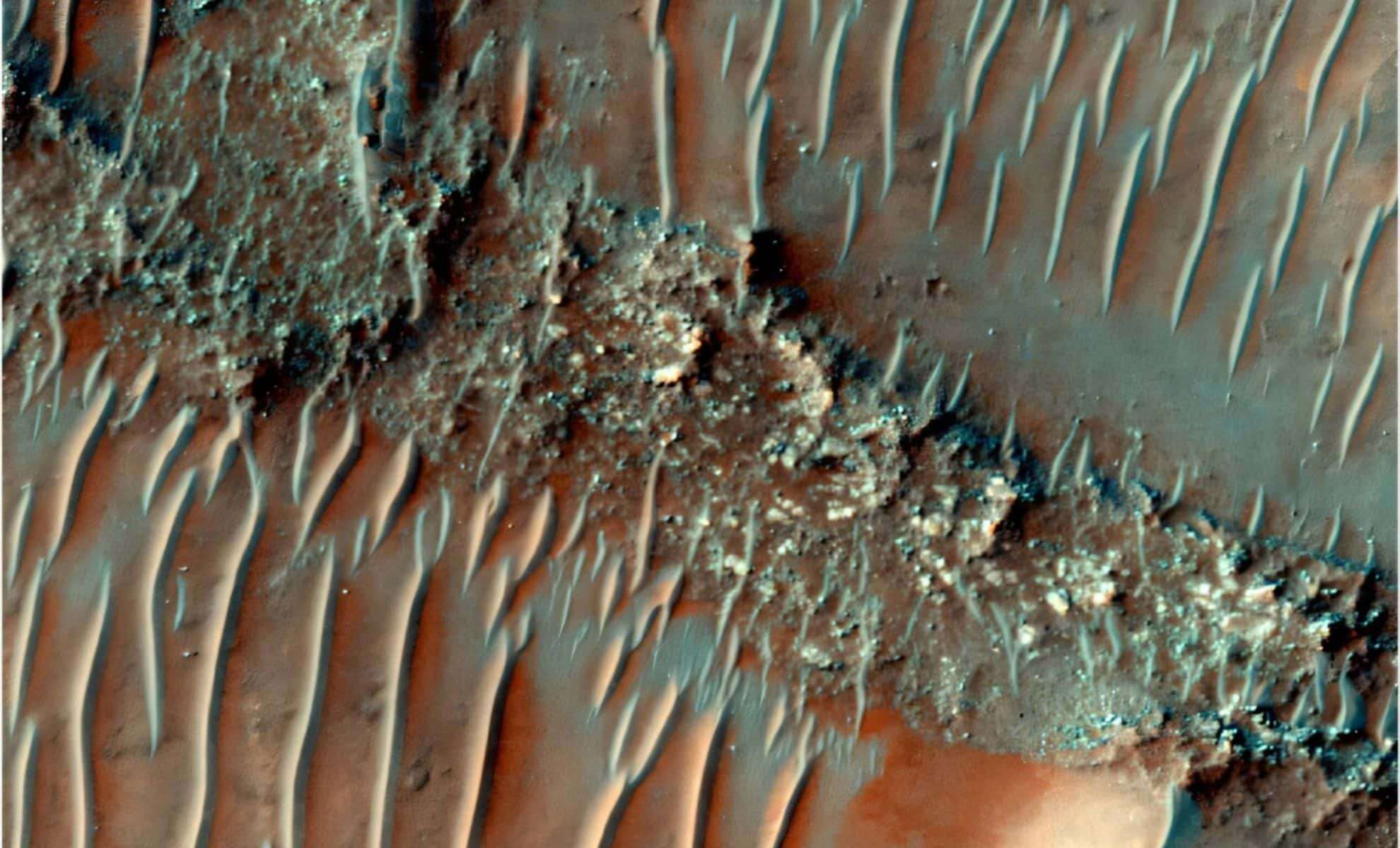
Mars, often called the Red Planet, was likely far more water-rich in its ancient past than previously assumed. Researchers have identified over 15,000 kilometers of ancient river networks in Mars’ Noachis Terra area, indicating that liquid water shaped much of the planet’s surface through precipitation-driven flow.
Unearthing a Forgotten Martian River Network
The study, spearheaded by Open University PhD candidate Adam Losekoot, revealed a series of fluvial sinuous ridges—also called inverted channels—spread across Noachis Terra. These features formed where river sediments solidified and later became exposed as softer surrounding materials eroded away. The extent of these channels, stretching more than 15,000 kilometers, offers robust evidence of a once watery Mars.
In contrast to the valley networks found in other Martian regions, these ridges suggest a long-lasting presence of surface water, contesting earlier ideas that Mars remained mostly cold and arid. Scientists believe rainfall contributed to the formation of these ancient waterways.

Insights Into Mars’ Ancient Environmental Conditions
For decades, Mars has intrigued scientists seeking signs of past life, with most evidence for historical water based on valley networks formed by runoff and precipitation. However, Noachis Terra has not received as much attention because it hosts fewer valley formations.
Instead, researchers concentrated on the fluvial sinuous ridges, providing new clues about ancient waterways on Mars.
The investigation suggests that stable surface water persisted in Noachis Terra during the Noachian-Hesperian boundary, around 3.7 billion years ago, a time marking a major shift in Mars’ climate and geology. These wet conditions would have significantly influenced the planet’s surface development.
High-Tech Tools Reveal Martian History
The team applied data from three main orbital instruments: the Context Camera (CTX), the Mars Orbiter Laser Altimeter (MOLA), and the High-Resolution Imaging Science Experiment (HiRISE). These devices enabled the detailed mapping of ridge locations, their lengths, and shapes across Noachis Terra. Many ridges are isolated, while others extend hundreds of kilometers, soaring tens of meters above adjacent terrain.
The ridges’ size and layout indicate that Mars maintained relatively stable surface conditions over long geological intervals, implying that precipitation-driven water flow was more sustained and widespread than formerly believed.
Reconsidering Mars’ Dry Past
This discovery challenges previous views suggesting Mars was predominantly cold and dry, experiencing only fleeting warm periods capable of sustaining liquid water. Instead, the findings point to extended intervals when the planet’s climate was wetter and more temperate.
Losekoot highlighted the significance of exploring relatively untouched regions like Noachis Terra, calling such sites natural time capsules preserving clues about Mars’ deep past.
- Categories:
- News


0 comments
Sign in to Comment