
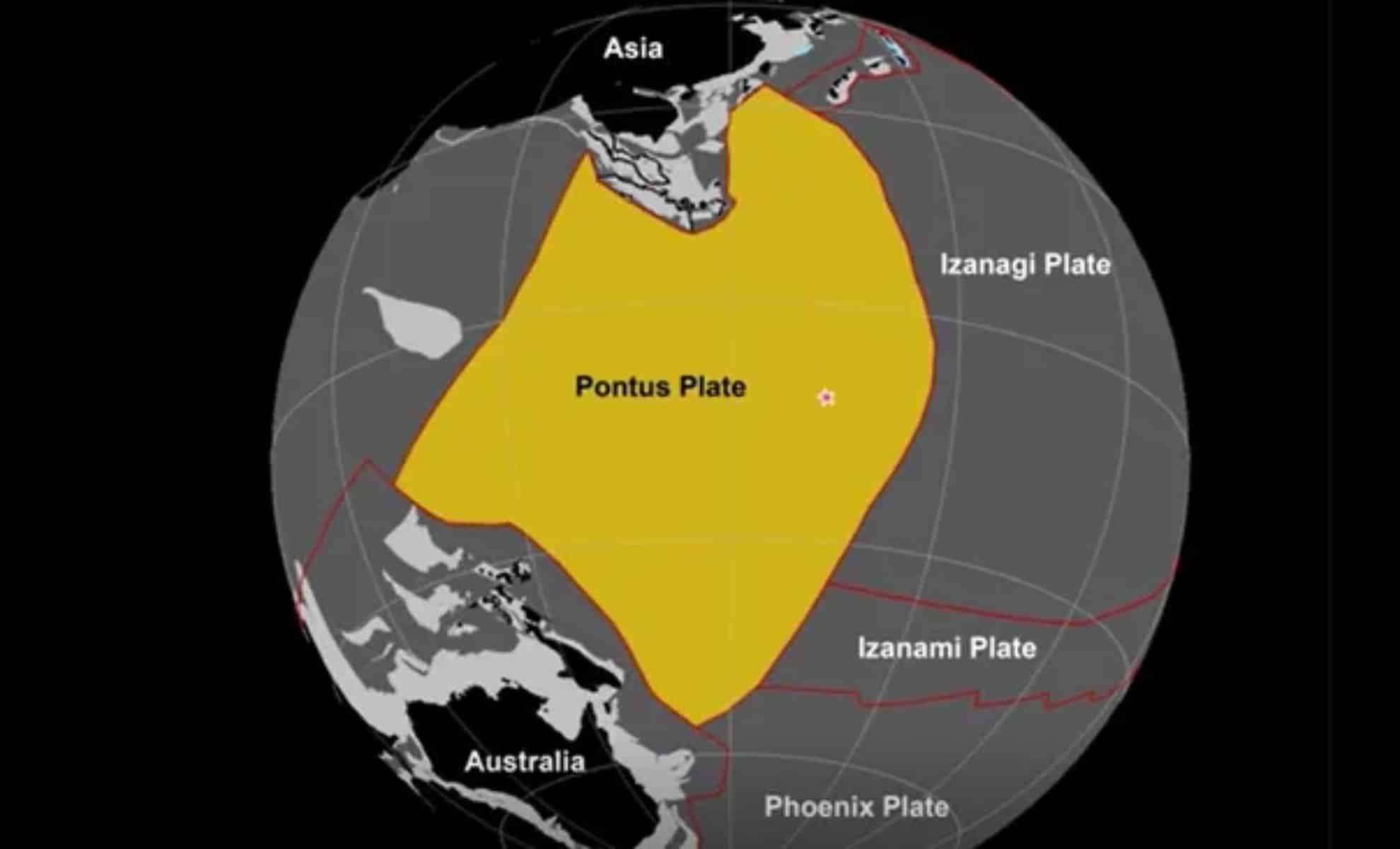
Researchers have identified the remnants of a colossal tectonic plate beneath the Pacific Ocean, a plate that had remained hidden for over 160 million years. This plate, named Pontus, once occupied about 25% of the Pacific basin. Although its presence had been hypothesized for some time, it was only through advancements in seismic imaging, extensive fieldwork, and sophisticated computer simulations that its existence was verified.
The Reemergence of a Forgotten Plate
Scientists initially suspected the buried presence of Pontus beneath the western Pacific more than ten years ago, when unusual seismic wave patterns were detected traveling through Earth’s mantle. These anomalies, often linked to irregular temperature distributions and unique mineral compositions deep underground, provided early hints of an unidentified tectonic entity. It was only after more in-depth investigations that the hypothesis became confirmed fact.
Leading the study, Suzanna van de Lagemaat from Utrecht University explained, “Initially, we believed the fragments belonged to a known lost plate. However, the magnetic properties of the rocks we analyzed revealed origins from much further north, indicating these samples came from an unknown tectonic plate.” Their published research sheds new light on ancient Pacific plate dynamics.

Until now, Pontus remained largely invisible in geological records, with only small remnants observable within mountain ranges of Japan, Borneo, the Philippines, New Guinea, and New Zealand. These fragments are vestiges left behind after subduction—the process where one tectonic plate is forced beneath another—gradually consumed Pontus beneath Earth's crust.
The Evolution and Demise of Pontus
Pontus originated approximately 160 million years ago and once extended over an area spanning around 15 million square miles—nearly a quarter of the Pacific Ocean's expanse. However, like many oceanic tectonic plates, it had a finite lifespan. Over time, subduction caused Pontus to sink deep into the mantle, erasing most of its geological footprint.
Its decline unfolded in a geologically intricate setting situated between two ancient oceanic bodies—Panthalassa and Tethys. This zone, between the future landmasses of Australia and Eurasia, experienced intense tectonic interactions including collisions and rapid formation of oceanic plates. Unlike continental crusts that preserve ancient records, oceanic crusts are frequently lost to mantle processes. In Pontus’s case, both the subducting and much of the overriding plates vanished, leaving minimal clues for geologists to investigate.
Piecing Together a Vast Ancient Tectonic Framework
Van de Lagemaat’s team reconstructed the extensive tectonic framework stretching from southern Japan down to New Zealand. By integrating paleomagnetic measurements, seismic imaging, and records from mountain-building episodes, the study revealed that Pontus formed a central part of an interconnected tectonic system persisting for more than 150 million years.
Through analysis of oceanic rock samples and tectonic plate motions, the scientists tracked ancient movements across the Pacific. Crucially, fossils from northern Borneo provided key evidence confirming Pontus’s northern starting point. Van de Lagemaat stated, “The magnetic signatures confirmed origins far north of what we initially expected.” This insight expanded the known scope of this now-recognized tectonic plate.
Moreover, the research hints that the famed Hawaii-Emperor Bend—a major shift in the Pacific Plate about 50 million years ago—might be linked to structural changes triggered by a forearc region collapse. This event was possibly due not to subduction but to alterations in the motions between the Pacific and Australian plates.
- Categories:
- News


0 comments
Sign in to Comment