
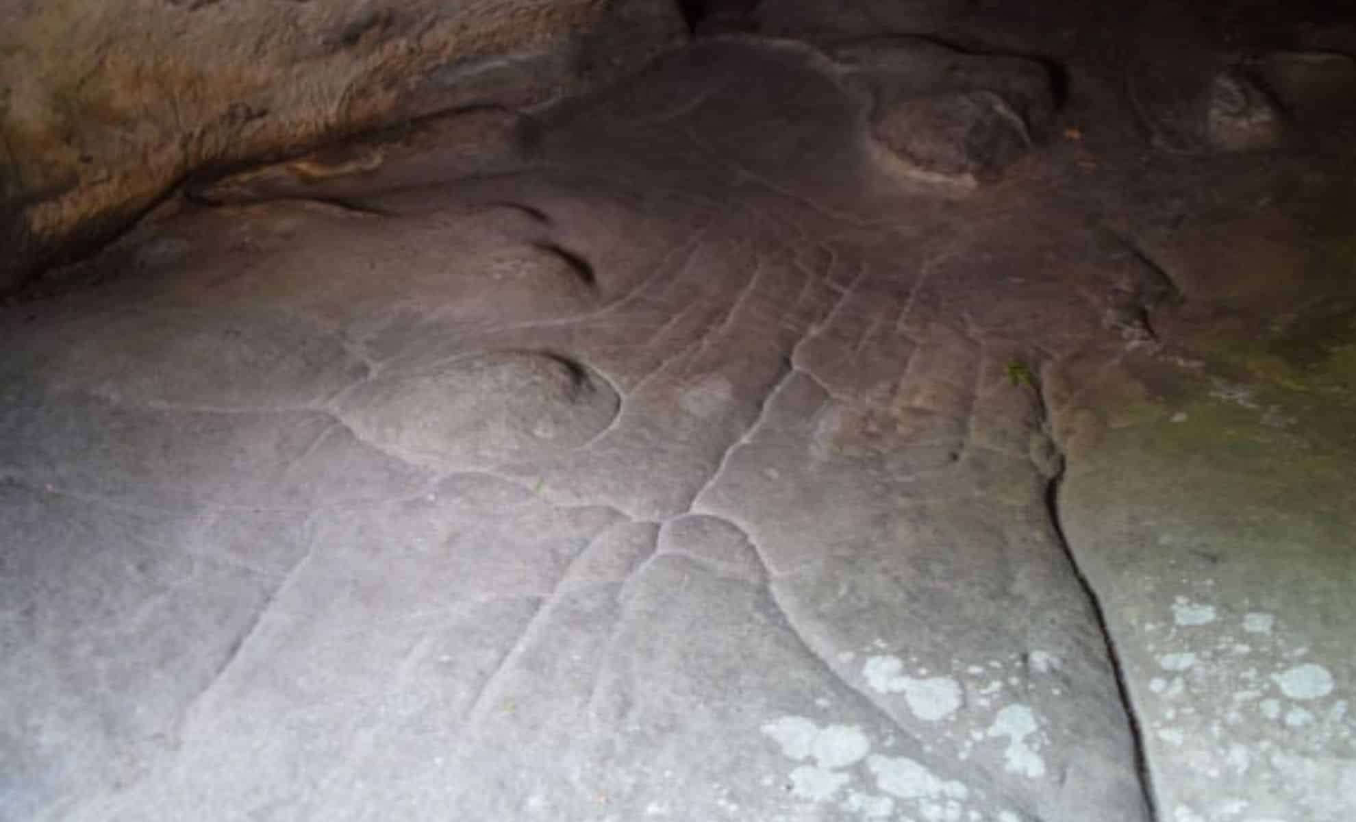
Scientists have uncovered what may be the earliest known 3D topographical model, an extraordinary Paleolithic artifact that transforms our understanding of ancient cartography. Discovered within the Ségognole 3 rock shelter located in the Paris Basin, this remarkable sandstone carving, dating back roughly 13 millennia, offers a remarkable window into the expertise of prehistoric societies. The sculpted stone floor portrays an intricate representation of the local terrain, highlighting knowledge of natural waterways and geological formations.
This incredible find overturns previous assumptions about early humans, demonstrating their sophisticated interpretation and manipulation of the environment, far exceeding what was once considered possible. What insights does this miniature three-dimensional landscape provide about the worldview of our ancestors, and why did it hold such significance?
A Practical yet Symbolically Rich Terrain Model
Initially, the carved sandstone in Ségognole 3 appeared as natural rock shapes. However, closer study revealed elaborate engravings that mirror the actual flow of water through the landscape. Dr. Anthony Milnes, an archaeologist from the University of Adelaide, characterized the item as “a three-dimensional miniature illustrating the dynamics of the landscape, including runoff from upland areas to streams and rivers, valley junctions, and downstream formations like lakes and wetlands.”

Unlike conventional maps focusing on scale and direction, this artifact visually emphasizes the movement patterns of water through terrain features. Dr. Milnes explains, “For Paleolithic communities, awareness of water pathways and key landscape traits was likely far more crucial than the modern ideas of distance and travel time.”
Advanced Craftsmanship and Symbolism
What stands out most about this find is the remarkable engineering skill involved. The Paleolithic creators meticulously shaped the sandstone so that rainfall would follow designated paths, demonstrating a sophisticated grasp of water behavior and environmental design. Dr. Médard Thiry of MINES Paris – PSL remarks, “Our investigations revealed that Paleolithic humans fashioned the sandstone to channel rainwater along specific routes, a insight previously unrecognized by archaeologists.”
Beyond practical uses, these detailed carvings likely held spiritual connotations related to water. Dr. Thiry suggests, “These features probably embody a deeper, symbolic meaning connected to water.”
The proximity of this water model to a sexual symbolic carving implies a profound link between water and fertility or life itself. “Both hydraulic structures—the sexual depiction and the miniature landform—are situated 2-3 meters apart, conveying a significant meaning about nature and life’s origins, although the full interpretation escapes us,” Dr. Thiry notes.
Rethinking Early Human Cognition
Previously, the oldest recognized map dated to around 3,000 years ago, a Bronze Age rock engraving. The Ségognole 3 3D model predates it by nearly ten millennia, significantly rewriting the timeline of ancient mapping. This artifact also offers compelling evidence of early humans' advanced cognitive abilities and problem-solving skills.
Dr. Milnes remarks, “This exceptional discovery reflects the imagination, mental acuity, and technical skill of our paleolithic forbears.” The study’s success is credited to interdisciplinary collaboration among archaeologists, geologists, and geomorphologists. Dr. Thiry stresses that such breakthroughs often emerge from intensive fieldwork and reconsideration of data.
Implications for Interpreting Prehistoric Cultures
The revelation of the oldest three-dimensional landscape model reshapes not only archaeological history but also our perception of early human-environment interactions. The capacity to recreate and control representations of natural water processes reveals an innovative mindset that blends engineering with ritual significance. This artifact integrates utility with spiritual depth, indicating that Paleolithic people regarded nature as both a practical resource and a source of profound meaning.
Dr. Thiry concludes, “This unprecedented find enriches our understanding of the capabilities and worldview of early humans.”
- Categories:
- News


0 comments
Sign in to Comment