
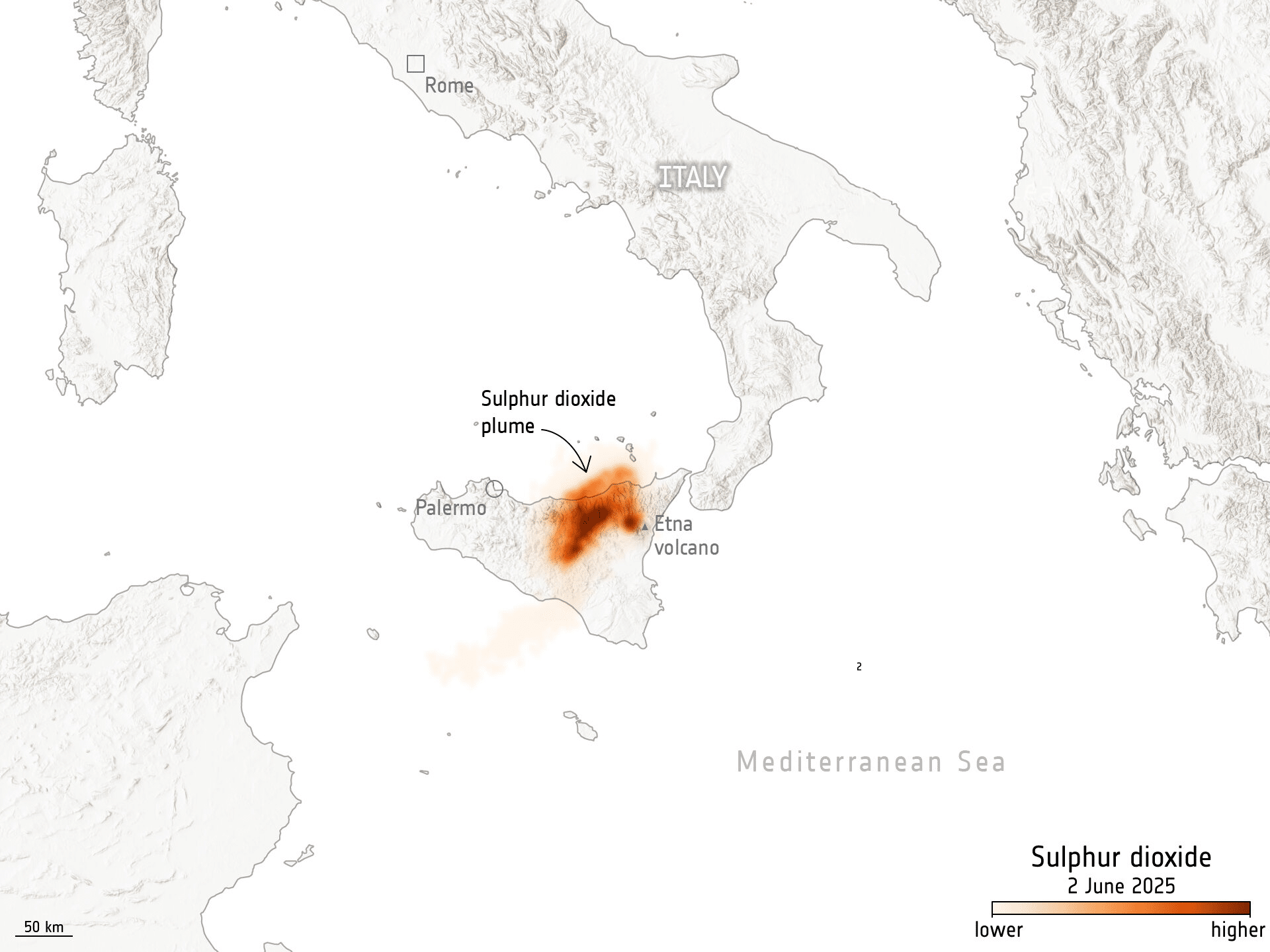
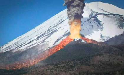
On June 2, 2025, Mount Etna, Europe’s most active volcano, unleashed a significant eruption that propelled a dense cloud of sulphur dioxide and ash high into the atmosphere, captivating observers worldwide. The European Space Agency’s (ESA) Copernicus Sentinel-5P satellite provided a remarkable satellite image that showcased the eruption’s expansive reach from orbit.
A Majestic Display of Nature’s Power at Mount Etna
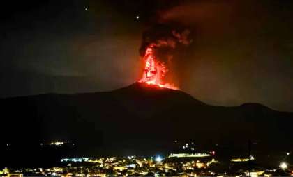
The June 2 eruption at Mount Etna represented a significant episode in the lifespan of this famously volatile volcano. While frequent eruptions are part of Etna’s natural cycle, this outburst stood out for the extraordinary volume of sulphur dioxide and particulate matter released. The resulting plume soared so high it was visible from space, with ESA’s Copernicus Sentinel-5P among the satellites tracking the event’s atmospheric footprint.
Local residents experienced a blend of fascination and anxiety as the eruption underscored the ongoing risks posed by the volcano. Italy’s National Institute of Geophysics and Volcanology reported that this was the most intense eruption since 2014. Experts continue to keep a close watch on Etna as it evolves, recognizing the potential for future major events that influence the region’s geography.

Tracking Atmospheric Changes with Copernicus Sentinel-5P
The Copernicus Sentinel-5P satellite, a key element of ESA’s Earth observation portfolio, played a vital role in documenting the gas emissions from Mount Etna. Specifically designed to analyze atmospheric composition, Sentinel-5P identified and mapped the sulphur dioxide cloud generated by the eruption. Known for its environmental impact, this gas contributes to phenomena like acid rain and plays a role in climate dynamics.
Data collected by Sentinel-5P offer crucial insights for scientists studying the atmosphere and environmental shifts caused by volcanic activity. By coordinating observations from multiple satellite platforms, researchers are better able to assess how these eruptions affect air quality and broader climatic trends over time.
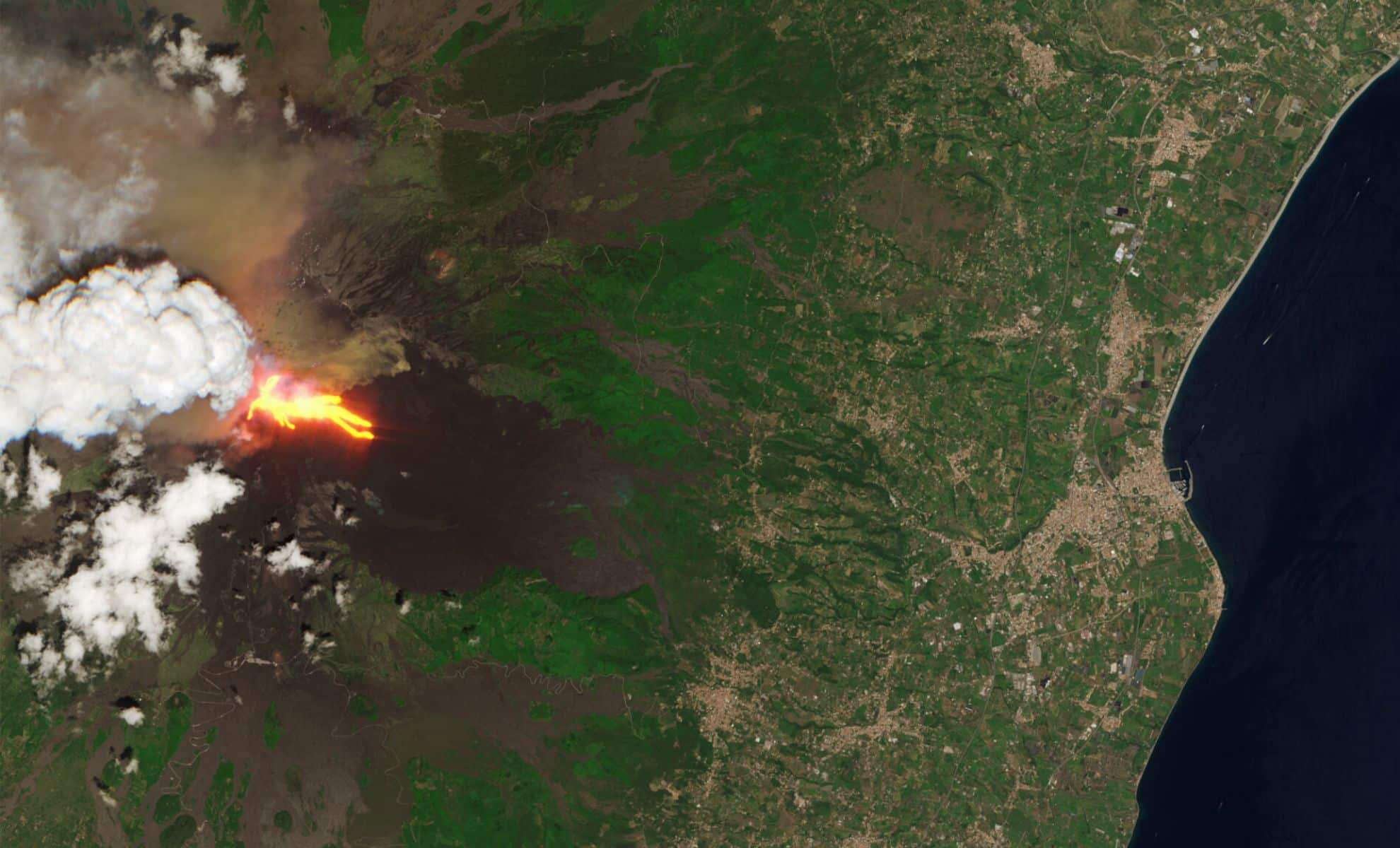
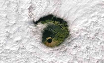
The Complementary Role of Sentinel-2’s Optical Imaging
Alongside Sentinel-5P’s atmospheric measurements, the Sentinel-2 mission supplied high-resolution optical imagery of the eruption site. Equipped with advanced sensors, Sentinel-2 captures detailed Earth surface visuals, documenting terrain alterations and the dispersion of volcanic debris such as ash layers and rock formations.
The fusion of data from both Sentinel-5P and Sentinel-2 has equipped scientists with a multidimensional view of Mount Etna’s eruption, combining atmospheric gas tracking with land surface changes. This integrated approach advances understanding of volcanic impacts and aids efforts to predict hazardous activity and improve emergency response planning.
Mount Etna’s Persistent Eruption Risks Across Europe
The recent eruption is part of Mount Etna’s continual cycle of activity, making it one of the planet’s most frequently erupting volcanoes. Over the years, these eruptions have posed challenges to local communities and ecosystems alike. Ash plumes regularly interfere with air traffic throughout Europe, while airborne particles can exacerbate respiratory conditions among nearby residents.
In addition to immediate hazards, Etna’s release of sulphur dioxide and other gases has far-reaching environmental implications. These emissions contribute to air pollution and may influence climate processes. Although a single eruption’s output appears limited, the cumulative effect of recurrent activity can impact environmental and atmospheric systems on broader scales.
- Categories:
- News


0 comments
Sign in to Comment